
Hurricane evacuation zones in New York City updated to include an additional 600,000
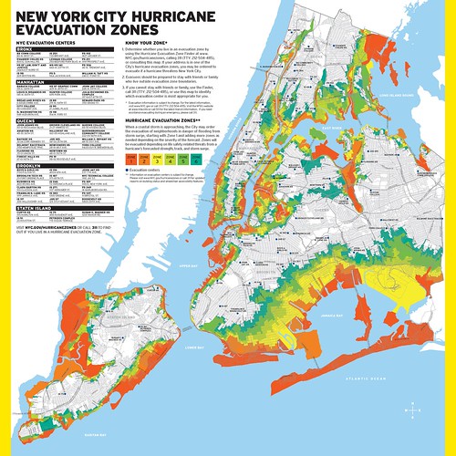 Today the final updates to the City’s Hurricane evacuation zones were announced. The new Zones, 1 through 6, will replace Zones A,B and C, now include an additional 600,000 New Yorkers not included within the boundaries of the former zones. The new zone system was developed using the latest Sea, Lake and Overland Surges from Hurricane storm surge inundation maps generated by the National Weather Service and processed by the US Army Corps of Engineers. The zones are based on coastal flood risk resulting from storm surge, the geography of the low-lying neighborhoods, and accessibility to these neighborhoods by bridges or roads. The new Zones will provide the City with more flexibility in targeting areas to evacuate in advance of a predicted storm.
The Office of Emergency Management also updated their Ready New York Hurricane Guide with the new evacuation zones and is available in print, online, in 11 languages and all households in an evacuation zone will receive a guide in the mail. The City also added features to its online Hurricane Evacuation Zone Finder, which is now mobile browser compatible and supports GPS. The Zone Finder indicates whether an evacuation is in effect and which zones are ordered to evacuate. The Finder can help users determine their zone by using GPS or an inputted address and then determines the nearest evacuation center.
New evacuation zones now include:
Residences of 37% of NYers
An additional 600,000 NYers
An additional 26 NYCHA developments
4 additional hospitals
9 additional nursing homes
All 6 Hurricane Evacuation Zones include a total population of 2,990,000 New Yorkers. NYC