
New Madrid earthquake, still considered the big one
Shortly after 2 o'clock on the morning of December 16, 1811, the Mississippi River valley was convulsed by an earthquake so severe that it awakened people in cities as distant as Pittsburgh, Pennsylvania, and Norfolk, Virginia. This shock inaugurated what must have been the most frightening sequence of earthquakes ever to occur in the United States. Intermittent strong shaking continued through March 1812 and aftershocks strong enough to be felt occurred through the year 1817. The initial earthquake of December 16 was followed by two other principal shocks, one on January 23, 1812, and the other on February 7, 1812. Judging from newspaper accounts of damage to buildings, the February 7 earthquake was the biggest of the three.
In the Mississippi and Ohio River valleys the earthquakes did much more than merely awaken sleepers. The scene was one of devastation in an area which is now the southeast part of Missouri, the northeast part of Arkansas, the southwest part of Kentucky, and the northwest part of Tennessee. Reelfoot Lake, in the northwest corner of Tennessee, stands today as evidence of the might of these great earthquakes. Stumps of trees killed by the sudden submergence of the ground can still be seen in Reelfoot Lake.
Uplift of over 3 meters was reported at one locality several hundred kilometers to the southwest of the epicentral zone where a lake formed by the St. Francis River had its water replaced by sand. Numerous dead fish were found in the former lake bottom. Large fissures, so wide that they could not be crossed on horseback, were formed in the soft alluvial ground. The earthquake made previously rich prairie land unfit for farming because of deep fissures, land subsidence which converted good fields to swamps, and numerous sand blows which covered the ground with sand and mud. The heavy damage inflicted on the land by these earthquakes led Congress to pass in 1815 the first disaster relief act providing the landowners of ravaged ground with an equal amount of land in unaffected regions.
Some of the most dramatic effects of the earthquakes occurred along rivers. Entire islands disappeared, banks caved into the rivers, and fissures opened and closed in the river beds. Water spouting from these fissures produced large waves in the river. New sections of river channel were formed and old channels cut off. Many boats were capsized and an unknown number of people were drowned. There are some graphic eyewitness descriptions in contemporary newspapers made by the boatmen caught on the Mississippi River near Little Prairie, not far from the present-day town of Caruthersville, Missouri.
Although the total number of deaths resulting from the earthquakes is unknown, the toll probably was not large because the area was sparsely populated and because the log cabin type construction that was prevalent at that time withstood the shaking very well. Masonry and stone structures did not fare so well, however, and damage to them was reported at distances of 250 kilometers and more. Chimneys were thrown down in Louisville, Kentucky, about 400 kilometers from the epicentral area, and were damaged at distances of 600 kilometers.
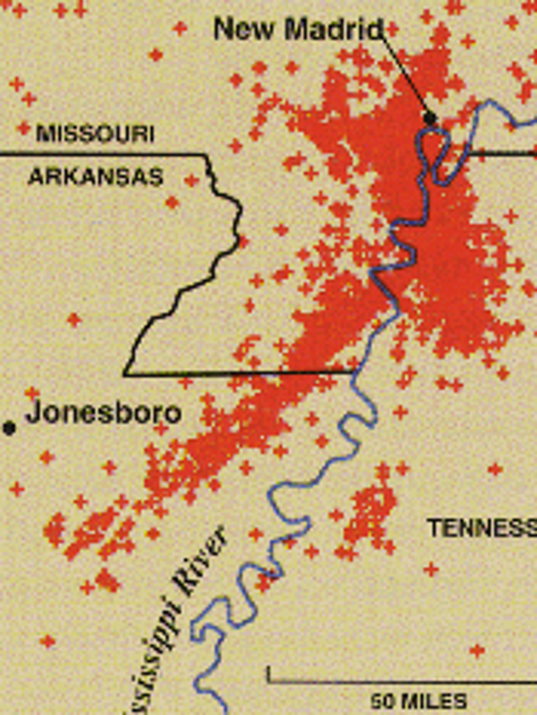
Although it is impossible to know the precise epicentral coordinates of the earthquakes, contemporary accounts of the events suggest that the epicenter of the December 16 shock was close to the southern limit of the area of sand blows. The epicenter of the February 7 shock was closer to the northern limit of the sand blows, near the town of New Madrid, Missouri. There is not sufficient information about the second main shock on January 23 to know its epicenter. Thus the common practice of calling the entire earthquake sequence the ``New Madrid earthquakes'' is somewhat misleading. From what is known about the present seismicity of the area, it can be inferred that their focal depths were probably between 5 and 20 kilometers. The fault plane -- or planes -- on which the Earth rupture occurred are inferred to have had a NNE - SSW strike direction, more or less parallel to the Mississippi River.
The felt areas of the three largest earthquakes were extremely large. They extended south to the gulf coast, southeast to the Atlantic coast, and northeast to Quebec, Canada. The western boundary cannot be established owing to a lack of population. However, it can be estimated that the area of intensity V or greater effects was approximately 2½ million square kilometers. This can be contrasted with the 1906 San Francisco earthquake, for which the area of intensity V or greater effects was about 150,000 square kilometers. The large difference in felt areas between the Mississippi Valley and San Francisco earthquakes, which had approximately the same magnitude and focal depth, can be explained by differences in attenuation of earthquake waves traveling through the Earth's outer crust. The crust in the Western United States tends to ``soak up'' earthquake energy, whereas in the central and eastern regions of the country the seismic energy experiences a much lower rate of absorption. Quantitative studies of recent earthquakes confirm this explanation. KGW